Weather Alert in Montana
Winter Weather Advisory issued February 8 at 12:34AM MST until February 9 at 11:00AM MST by NWS Great Falls MT
AREAS AFFECTED: East Glacier Park Region; Southern Rocky Mountain Front
DESCRIPTION: * WHAT...Snow expected. Total snow accumulations between 3 and 5 inches. Isolated snowfall accumulations near 12 inches at ridge tops. * WHERE...The Continental Divide along the Rocky Mountain Front. * WHEN...From 5 PM this afternoon to 11 AM MST Monday. * IMPACTS...Roads, and especially bridges and overpasses, will likely become slick and hazardous.
INSTRUCTION: To see a graphical representation of the degree of stress on young livestock please visit our webpage and select Local Programs then Cold Air Advisory for Newborn Livestock.
Want more detail? Get the Complete 7 Day and Night Detailed Forecast!
Current U.S. National Radar--Current
The Current National Weather Radar is shown below with a UTC Time (subtract 5 hours from UTC to get Eastern Time).

National Weather Forecast--Current
The Current National Weather Forecast and National Weather Map are shown below.

National Weather Forecast for Tomorrow
Tomorrow National Weather Forecast and Tomorrow National Weather Map are show below.

North America Water Vapor (Moisture)
This map shows recent moisture content over North America. Bright and colored areas show high moisture (ie, clouds); brown indicates very little moisture present; black indicates no moisture.

Weather Topic: What is Freezing Rain?
Home - Education - Precipitation - Freezing Rain
 Next Topic: Graupel
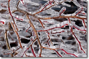
Freezing rain is a condition where precipitation which has fallen in the form of
water droplets reaches temperatures which are below freezing and freezes upon
coming into contact
with surface objects. The result of this precipitation is a glaze of ice which
can be damaging to plants and man-made structures. A severe onset of freezing
rain which results in a very thick glaze of ice is known as an ice storm.
Next Topic: Graupel
Weather Topic: What is Hail?
Home - Education - Precipitation - Hail
 Next Topic: Hole Punch Clouds
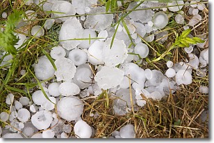
Hail is a form of precipitation which is recognized by large solid balls or
clumps of ice. Hail is created by thunderstorm clouds with strong updrafts of wind.
As the hailstones remain in the updraft, ice is deposited onto them until their
weight becomes heavy enough for them to fall to the earth's surface.
Hail storms can cause significant damage to crops, aircrafts, and man-made structures,
despite the fact that the duration is usually less than ten minutes.
Next Topic: Hole Punch Clouds
Current conditions powered by WeatherAPI.com


