Weather Alert in Ohio
Flood Warning issued April 1 at 10:10PM EDT until April 5 at 6:00AM EDT by NWS Cleveland OH
AREAS AFFECTED: Holmes, OH; Wayne, OH
DESCRIPTION: ...The Flood Warning is extended for the following rivers in Ohio... Portage River At Woodville affecting Sandusky and Wood Counties. Huron River Near Milan affecting Erie County. Cuyahoga River At Old Portage affecting Summit County. Blanchard River Near Findlay affecting Hancock County. Maumee River At Waterville affecting Lucas and Wood Counties. Killbuck Creek Near Killbuck affecting Holmes and Wayne Counties. ...The Flood Warning continues for the following rivers in Ohio... Sandusky River At Tiffin affecting Seneca County. Black River At Elyria affecting Lorain County. Mahoning River At Youngstown affecting Mahoning and Trumbull Counties. Eagle Creek Above Findlay affecting Hancock County. Eagle Creek At Phalanx Station affecting Trumbull County. For the Portage River...including Woodville...Minor flooding is forecast. For the Sandusky River...including Upper Sandusky, Fremont, Tiffin, Bucyrus...Minor flooding is forecast. For the Huron River...including Milan...Minor flooding is forecast. For the Black River...including Elyria...Minor flooding is forecast. For the Cuyahoga River...including Hiram Rapids, Jaite, Old Portage, Independence...Minor flooding is forecast. For the Blanchard River...including Findlay...Minor flooding is forecast. For the Maumee River...including Grand Rapids, Waterville...Minor flooding is forecast. For the Killbuck Creek...including Killbuck...Minor flooding is forecast. For the Mahoning River...including Leavittsburg, Warren, Youngstown...Minor flooding is forecast. For the Eagle Creek (Hancock)...including Findlay...Minor flooding is forecast. For the Eagle Creek (Trumbull)...including Phalanx Station...Minor flooding is forecast. * WHAT...Minor flooding is occurring and minor flooding is forecast. * WHERE...Killbuck Creek near Killbuck. * WHEN...Until Sunday morning. * IMPACTS...At 17.0 feet, Private property on Water Street in the Village of Killbuck flooded. Several county and local roads impassable including State Route 60 south and County Road 621. * ADDITIONAL DETAILS... - At 9:00 PM EDT Wednesday the stage was 15.4 feet. - Forecast...The river is expected to rise to a crest of 16.6 feet early tomorrow afternoon. It will then fall below flood stage early Sunday morning. - Flood stage is 15.0 feet. - Please visit www.weather.gov/safety/flood for flood safety and preparedness information.
INSTRUCTION: Turn around, don't drown when encountering flooded roads. Most flood deaths occur in vehicles. Additional information is available at www.weather.gov/cle. The next statement will be issued Thursday morning at 600 AM EDT.
Want more detail? Get the Complete 7 Day and Night Detailed Forecast!
Current U.S. National Radar--Current
The Current National Weather Radar is shown below with a UTC Time (subtract 5 hours from UTC to get Eastern Time).

National Weather Forecast--Current
The Current National Weather Forecast and National Weather Map are shown below.

National Weather Forecast for Tomorrow
Tomorrow National Weather Forecast and Tomorrow National Weather Map are show below.

North America Water Vapor (Moisture)
This map shows recent moisture content over North America. Bright and colored areas show high moisture (ie, clouds); brown indicates very little moisture present; black indicates no moisture.

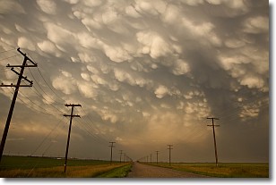
Weather Topic: What are Mammatus Clouds?
Home - Education - Cloud Types - Mammatus Clouds
 Next Topic: Nimbostratus Clouds
A mammatus cloud is a cloud with a unique feature which resembles
a web of pouches hanging along the base of the cloud.
In the United States, mammatus clouds tend to form in the warmer months, commonly
in the Midwest and eastern regions.
While they usually form at the bottom of a cumulonimbis cloud, they can also form
under altostratus, altocumulus, stratocumulus, and cirrus clouds. Mammatus clouds
warn that severe weather is close.
Next Topic: Nimbostratus Clouds
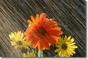
Weather Topic: What is Precipitation?
Home - Education - Precipitation - Precipitation
 Next Topic: Rain
Precipitation can refer to many different forms of water that
may fall from clouds. Precipitation occurs after a cloud has become saturated to
the point where its water particles are more dense than the air below the cloud.
In most cases, precipitation will reach the ground, but it is not uncommon for
precipitation to evaporate before it reaches the earth's surface.
When precipitation evaporates before it contacts the ground it is called Virga.
Graupel, hail, sleet, rain, drizzle, and snow are forms of precipitation, but fog
and mist are not considered precipitation because the water vapor which
constitutes them isn't dense enough to fall to the ground.
Next Topic: Rain
Current conditions powered by WeatherAPI.com


