Weather Alert in Alaska
Extreme Cold Watch issued February 7 at 1:27PM AKST until February 11 at 6:00PM AKST by NWS Fairbanks AK
AREAS AFFECTED: Western Arctic Coast; Northwest Arctic Coast; Northern Arctic Coast; Central Beaufort Sea Coast; Eastern Beaufort Sea Coast; Western Arctic Plains; Howard Pass and the Delong Mountains; Central Arctic Plains; Central Brooks Range; Romanzof Mountains
DESCRIPTION: * WHAT...Dangerously cold wind chills as low as 75 below possible. * WHERE...Arctic Coast, Arctic Plains, and Brooks Range Passes. * WHEN...From Sunday evening through Wednesday afternoon. * IMPACTS...The dangerously cold wind chills as low as 75 below zero could cause frostbite on exposed skin in as little as 5 minutes. * ADDITIONAL DETAILS...Moderate winds between 5 to 10 mph are expected to start as early as Sunday night, with increasing winds around 15 to 20 mph expected to peak Tuesday into Wednesday along the Eastern Arctic Coast. Winds gusts may be as high as 60 mph along the Chukchi Sea Coast, while winds in Atigun Pass will remain gusty. This coupled with ambient air temperatures as low as 50 below Monday night into Tuesday, will allow for dangerously cold wind chills to impact much of the Arctic Coast through midweek.
INSTRUCTION: Dress in layers including a hat, face mask, and gloves if you must go outside.
Want more detail? Get the Complete 7 Day and Night Detailed Forecast!
Current U.S. National Radar--Current
The Current National Weather Radar is shown below with a UTC Time (subtract 5 hours from UTC to get Eastern Time).

National Weather Forecast--Current
The Current National Weather Forecast and National Weather Map are shown below.

National Weather Forecast for Tomorrow
Tomorrow National Weather Forecast and Tomorrow National Weather Map are show below.

North America Water Vapor (Moisture)
This map shows recent moisture content over North America. Bright and colored areas show high moisture (ie, clouds); brown indicates very little moisture present; black indicates no moisture.

Weather Topic: What is Graupel?
Home - Education - Precipitation - Graupel
 Next Topic: Hail
Graupel is a form of precipitation that is created by atmospheric conditions
which cause supercooled water droplets to contact snow crystals and freeze to
their surface.
Sometimes known as soft hail or snow pellets, graupel is delicate and easily
destroyed by touch. Whereas hail usually falls during severe weather, graupel
doesn't require such conditions to form, and can form in mild precipitation
similar to situations which produce snowfall.
Next Topic: Hail
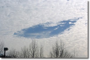
Weather Topic: What are Hole Punch Clouds?
Home - Education - Cloud Types - Hole Punch Clouds
 Next Topic: Mammatus Clouds
A hole punch cloud is an unusual occurrence when a disk-shaped
hole appears in a cirrostratus, cirrocumulus, or altocumulus cloud.
When part of the cloud forms ice crystals, water droplets in the surrounding area
of the cloud evaporate. The effect of this process produces a large elliptical
gap in the cloud. The hole punch cloud formation is rare, but it is not specific
to any geographic area.
Other names which have been used to describe this phenomena include fallstreak hole,
skypunch, and cloud hole.
Next Topic: Mammatus Clouds
Current conditions powered by WeatherAPI.com


