Weather Alert in California
Winter Storm Warning issued February 15 at 9:57AM PST until February 19 at 9:00AM PST by NWS San Diego CA
AREAS AFFECTED: San Bernardino County Mountains
DESCRIPTION: * WHAT...Heavy snow expected. For first round Monday into early Tuesday, 6-10 inches expected between 6000-7000 ft, 10-18 inches expected 7000-8000 ft, and up to 30 inches above 8000 ft. South winds gusting to 40-60 mph on the ridges and desert slopes. Occasional light snow showers Tuesday. Widespread moderate snow late Tuesday into Wednesday morning, with additional totals 8-15 inches between 6000-7500 ft. Light snow showers expected Thursday. Stronger southwest winds with gusts in excess of 70 mph along the desert slopes possible late Tuesday and Wednesday. A few additional inches of snow expected Thursday. * WHERE...San Bernardino County Mountains. * WHEN...From 10 AM Monday to 9 AM PST Thursday. * IMPACTS...Travel could be very difficult to impossible. The hazardous conditions could impact the Monday morning and evening commutes. Very strong winds could cause extensive tree damage. * ADDITIONAL DETAILS...For the first round Monday, snow levels will start around 6800-7500 ft and fall to near 5000 ft by early Tuesday morning. Snow levels lowering to around 4000 ft Wednesday morning. Impacts to I-15 near the summit of the Cajon Pass possible Wednesday morning and Thursday morning.
INSTRUCTION: If you must travel, keep an extra flashlight, food, and water in your vehicle in case of an emergency. The latest road conditions for the state you are calling from can be obtained by calling 5 1 1.
Want more detail? Get the Complete 7 Day and Night Detailed Forecast!
Current U.S. National Radar--Current
The Current National Weather Radar is shown below with a UTC Time (subtract 5 hours from UTC to get Eastern Time).

National Weather Forecast--Current
The Current National Weather Forecast and National Weather Map are shown below.

National Weather Forecast for Tomorrow
Tomorrow National Weather Forecast and Tomorrow National Weather Map are show below.

North America Water Vapor (Moisture)
This map shows recent moisture content over North America. Bright and colored areas show high moisture (ie, clouds); brown indicates very little moisture present; black indicates no moisture.

Weather Topic: What is Freezing Rain?
Home - Education - Precipitation - Freezing Rain
 Next Topic: Graupel
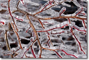
Freezing rain is a condition where precipitation which has fallen in the form of
water droplets reaches temperatures which are below freezing and freezes upon
coming into contact
with surface objects. The result of this precipitation is a glaze of ice which
can be damaging to plants and man-made structures. A severe onset of freezing
rain which results in a very thick glaze of ice is known as an ice storm.
Next Topic: Graupel
Weather Topic: What is Hail?
Home - Education - Precipitation - Hail
 Next Topic: Hole Punch Clouds
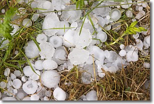
Hail is a form of precipitation which is recognized by large solid balls or
clumps of ice. Hail is created by thunderstorm clouds with strong updrafts of wind.
As the hailstones remain in the updraft, ice is deposited onto them until their
weight becomes heavy enough for them to fall to the earth's surface.
Hail storms can cause significant damage to crops, aircrafts, and man-made structures,
despite the fact that the duration is usually less than ten minutes.
Next Topic: Hole Punch Clouds
Current conditions powered by WeatherAPI.com


