Weather Alert in Wisconsin
Winter Storm Watch issued April 2 at 2:21AM CDT until April 4 at 10:00AM CDT by NWS Green Bay WI
AREAS AFFECTED: Oneida; Forest
DESCRIPTION: * WHAT...For the Ice Storm Warning, significant icing expected. Total snow and sleet accumulations up to one inch and ice accumulations between two tenths and one half of an inch. Winds gusting as high as 35 mph. For the Winter Storm Watch, significant icing possible. Total ice accumulations between one quarter and three tenths of an inch possible. * WHERE...Oneida and Forest Counties. * WHEN...For the Ice Storm Warning, from 5 AM early this morning to 1 AM CDT Friday. For the Winter Storm Watch, from Friday evening through Saturday morning. * IMPACTS...Power outages and tree damage are likely due to the ice. Travel could be hazardous due to icy roads. The hazardous conditions will impact the Thursday morning and evening commutes.
INSTRUCTION: Travel is strongly discouraged. If you must travel, keep an extra flashlight, food and water in your vehicle in case of an emergency. Prepare for possible power outages. The latest road conditions can be obtained by calling 5 1 1. For the Winter Storm Watch, monitor the latest forecasts for updates on this situation.
Want more detail? Get the Complete 7 Day and Night Detailed Forecast!
Current U.S. National Radar--Current
The Current National Weather Radar is shown below with a UTC Time (subtract 5 hours from UTC to get Eastern Time).

National Weather Forecast--Current
The Current National Weather Forecast and National Weather Map are shown below.

National Weather Forecast for Tomorrow
Tomorrow National Weather Forecast and Tomorrow National Weather Map are show below.

North America Water Vapor (Moisture)
This map shows recent moisture content over North America. Bright and colored areas show high moisture (ie, clouds); brown indicates very little moisture present; black indicates no moisture.

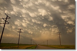
Weather Topic: What are Mammatus Clouds?
Home - Education - Cloud Types - Mammatus Clouds
 Next Topic: Nimbostratus Clouds
A mammatus cloud is a cloud with a unique feature which resembles
a web of pouches hanging along the base of the cloud.
In the United States, mammatus clouds tend to form in the warmer months, commonly
in the Midwest and eastern regions.
While they usually form at the bottom of a cumulonimbis cloud, they can also form
under altostratus, altocumulus, stratocumulus, and cirrus clouds. Mammatus clouds
warn that severe weather is close.
Next Topic: Nimbostratus Clouds
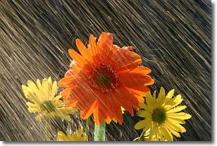
Weather Topic: What is Precipitation?
Home - Education - Precipitation - Precipitation
 Next Topic: Rain
Precipitation can refer to many different forms of water that
may fall from clouds. Precipitation occurs after a cloud has become saturated to
the point where its water particles are more dense than the air below the cloud.
In most cases, precipitation will reach the ground, but it is not uncommon for
precipitation to evaporate before it reaches the earth's surface.
When precipitation evaporates before it contacts the ground it is called Virga.
Graupel, hail, sleet, rain, drizzle, and snow are forms of precipitation, but fog
and mist are not considered precipitation because the water vapor which
constitutes them isn't dense enough to fall to the ground.
Next Topic: Rain
Current conditions powered by WeatherAPI.com


