Weather Alert in Alaska
Hydrologic Outlook issued August 30 at 9:40PM AKDT by NWS Fairbanks AK
AREAS AFFECTED: Fairbanks Metro Area
DESCRIPTION: ESFAFG As of 9 PM on Saturday, the Tanana River at Fairbanks has risen to 23.74 feet and water levels are still rising. Flooding impacts are not expected at this time, but those near the Tanana River outside of the dike may observe high groundwater levels. While it is still somewhat uncertain exactly how much the Tanana will rise before cresting and receding, river levels will likely approach 24 feet either tomorrow or Labor Day. At this level, while no specific flood impacts will be realized, bankfull conditions will be noted in the vicinity of Old Richardson Hwy in Salcha, and water may begin to spill over the bank and approach Ruger Trail near Bradbury Road. Tanana River water has a history of beginning to flow into the Piledriver Slough as well when river levels in the Tanana at Fairbanks reach 24 feet. Additional rainfall amounts over the next few days in Fairbanks and upstream areas are expected to remain under a quarter of an inch. As such, any further rainfall this weekend is not expected to bring additional impacts to locations in Fairbanks near the Tanana.
INSTRUCTION: N/A
Want more detail? Get the Complete 7 Day and Night Detailed Forecast!
Current U.S. National Radar--Current
The Current National Weather Radar is shown below with a UTC Time (subtract 5 hours from UTC to get Eastern Time).

National Weather Forecast--Current
The Current National Weather Forecast and National Weather Map are shown below.

National Weather Forecast for Tomorrow
Tomorrow National Weather Forecast and Tomorrow National Weather Map are show below.

North America Water Vapor (Moisture)
This map shows recent moisture content over North America. Bright and colored areas show high moisture (ie, clouds); brown indicates very little moisture present; black indicates no moisture.

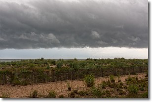
Weather Topic: What are Shelf Clouds?
Home - Education - Cloud Types - Shelf Clouds
 Next Topic: Sleet
A shelf cloud is similar to a wall cloud, but forms at the front
of a storm cloud, instead of at the rear, where wall clouds form.
A shelf cloud is caused by a series of events set into motion by the advancing
storm; first, cool air settles along the ground where precipitation has just fallen.
As the cool air is brought in, the warmer air is displaced, and rises above it,
because it is less dense. When the warmer air reaches the bottom of the storm cloud,
it begins to cool again, and the resulting condensation is a visible shelf cloud.
Next Topic: Sleet
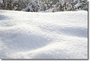
Weather Topic: What is Snow?
Home - Education - Precipitation - Snow
 Next Topic: Stratocumulus Clouds
Snow is precipitation taking the form of ice crystals. Each ice crystal, or snowflake,
has unique characteristics, but all of them grow in a hexagonal structure.
Snowfall can last for sustained periods of time and result in significant buildup
of snow on the ground.
On the earth's surface, snow starts out light and powdery, but as it begins to melt
it tends to become more granular, producing small bits of ice which have the consistency of
sand. After several cycles of melting and freezing, snow can become very dense
and ice-like, commonly known as snow pack.
Next Topic: Stratocumulus Clouds
Current conditions powered by WeatherAPI.com


