Weather Alert in Washington
Flood Warning issued March 29 at 2:11PM PDT until April 5 at 8:30AM PDT by NWS Spokane WA
AREAS AFFECTED: Chelan, WA
DESCRIPTION: * WHAT...Flooding caused by snowmelt continues for the lower Stehekin Valley. * WHERE...A portion of North Central Washington, including the following county, Chelan. * WHEN...Until further notice. * IMPACTS...When the Stehekin River gauge hits 19.3 feet, water breaches the river bank. At 20 feet, water inundates some properties and overtops the temporary corduroy bridge. Company Creek Road begins to flood in places at the northern end and Battalion Creek culverts are beginning to be overtopped. At 20.5 feet, water begins to damage Wood Road. * ADDITIONAL DETAILS... - At 208 PM PDT, Snowmelt continues to contribute to high floods and flooding on the Stehekin River. - Little precipitation over the past couple of days has allowed the Stehekin River to slowly recede. This trend will continue through the week, but it is forecasted to remain near or above 20 feet until further notice. - http://www.weather.gov/safety/flood
INSTRUCTION: Flooding is occurring. It is important to know where you are relative to streams, rivers, or creeks. Campers and hikers should avoid streams or creeks.
Want more detail? Get the Complete 7 Day and Night Detailed Forecast!
Current U.S. National Radar--Current
The Current National Weather Radar is shown below with a UTC Time (subtract 5 hours from UTC to get Eastern Time).

National Weather Forecast--Current
The Current National Weather Forecast and National Weather Map are shown below.

National Weather Forecast for Tomorrow
Tomorrow National Weather Forecast and Tomorrow National Weather Map are show below.

North America Water Vapor (Moisture)
This map shows recent moisture content over North America. Bright and colored areas show high moisture (ie, clouds); brown indicates very little moisture present; black indicates no moisture.

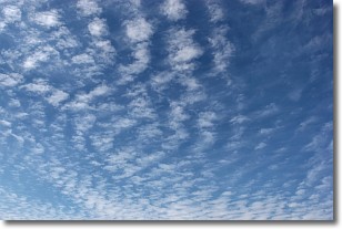
Weather Topic: What are Altocumulus Clouds?
Home - Education - Cloud Types - Altocumulus Clouds
 Next Topic: Altostratus Clouds
Similar to cirrocumulus clouds, altocumulus clouds are
characterized by cloud patches. They are distinguished by larger cloudlets
than cirrocumulus clouds but are still smaller than stratocumulus clouds.
Altocumulus clouds most commonly form in middle altitudes (between 2 and 5 km)
and may resemble, at times, the shape of a flying saucer.
These uncommon formations, called altocumulus lenticularis, are created by uplift
in the atmosphere and are most often seen in close proximity to mountains.
Next Topic: Altostratus Clouds
Weather Topic: What are Cirrocumulus Clouds?
Home - Education - Cloud Types - Cirrocumulus Clouds
 Next Topic: Cirrostratus Clouds
Cirrocumulus clouds form at high altitudes (usually around 5 km)
and have distinguishing characteristics displayed in a fine layer of
small cloud patches. These small cloud patches are sometimes referred to as
"cloudlets" in relation to the whole cloud formation.
Cirrocumulus clouds are formed from ice crystals and water droplets. Often, the
water droplets in the cloud freeze into ice crystals and the cloud becomes a
cirrostratus cloud. Because of this common occurrence, cirrocumulus cloud
formations generally pass rapidly.
Next Topic: Cirrostratus Clouds
Current conditions powered by WeatherAPI.com


