Weather Alert in Colorado
Avalanche Advisory issued February 27 at 5:49PM MST by NWS Denver CO
AREAS AFFECTED: Gore and Elk Mountains/Central Mountain Valleys; South and East Jackson/Larimer/North and Northeast Grand/Northwest Boulder Counties Above 9000 Feet; South and Southeast Grand/West Central and Southwest Boulder/Gilpin/Clear Creek/Summit/North and West Park Counties Above 9000 Feet; Western Mosquito Range/East Lake County Above 11000 Ft; Eastern Sawatch Mountains above 11000 Ft; Western Chaffee County Between 9000 and 11000 Ft
DESCRIPTION: SABCO THE FOLLOWING MESSAGE IS TRANSMITTED AT THE REQUEST OF THE COLORADO AVALANCHE INFORMATION CENTER. ...A SPECIAL AVALANCHE ADVISORY IN EFFECT FROM FRIDAY EVENING THROUGH SUNDAY... *WHAT...It is very easy for people to trigger large and deadly avalanches through the weekend. *WHERE...The Never Summer Mountains south over Berthoud Pass and Loveland Pass into Summit County, the Gore Range, and the northern Sawatch. *WHEN...Dangerous avalanche conditions exist through Sunday. *IMPACTS...Very large and dangerous avalanches will be easy to trigger. *PRECAUTION/PREPAREDNESS ACTIONS...These are the most dangerous conditions we have experienced all season. You can trigger a very large avalanche from a distance or from below. You may get no warning signs before you trigger a deadly avalanche. Careful planning and conservative terrain selection are essential for safe travel in backcountry avalanche terrain. Avoid travel on or under slopes steeper than 30 degrees. You can find more detailed information at colorado.gov/avalanche Pritchett
INSTRUCTION: N/A
Want more detail? Get the Complete 7 Day and Night Detailed Forecast!
Current U.S. National Radar--Current
The Current National Weather Radar is shown below with a UTC Time (subtract 5 hours from UTC to get Eastern Time).

National Weather Forecast--Current
The Current National Weather Forecast and National Weather Map are shown below.

National Weather Forecast for Tomorrow
Tomorrow National Weather Forecast and Tomorrow National Weather Map are show below.

North America Water Vapor (Moisture)
This map shows recent moisture content over North America. Bright and colored areas show high moisture (ie, clouds); brown indicates very little moisture present; black indicates no moisture.

Weather Topic: What is Sleet?
Home - Education - Precipitation - Sleet
 Next Topic: Snow
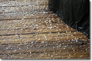
Sleet is a form of precipitation in which small ice pellets are the primary
components. These ice pellets are smaller and more translucent than hailstones,
and harder than graupel. Sleet is caused by specific atmospheric conditions and
therefore typically doesn't last for extended periods of time.
The condition which leads to sleet formation requires a warmer body of air to be
wedged in between two sub-freezing bodies of air. When snow falls through a warmer
layer of air it melts, and as it falls through the next sub-freezing body of air
it freezes again, forming ice pellets known as sleet. In some cases, water
droplets don't have time to freeze before reaching the surface and the result is
freezing rain.
Next Topic: Snow
Weather Topic: What are Stratocumulus Clouds?
Home - Education - Cloud Types - Stratocumulus Clouds
 Next Topic: Stratus Clouds
Stratocumulus clouds are similar to altocumulus clouds in their
fluffy appearance, but have a slightly darker shade due to their additional mass.
A good way to distinguish the two cloud types is to hold your hand out and measure
the size of an individual cloud; if it is the size of your thumb it is generally
an altocumulus cloud, if it is the size of your hand it is generally a
stratocumulus cloud.
It is uncommon for stratocumulus clouds to produce precipitation, but if they do
it is usually a light rain or snow.
Next Topic: Stratus Clouds
Current conditions powered by WeatherAPI.com


