Weather Alert in California
Winter Weather Advisory issued February 15 at 9:18PM PST until February 18 at 4:00PM PST by NWS San Francisco CA
AREAS AFFECTED: Santa Lucia Mountains and Los Padres National Forest; Mountains Of San Benito County And Interior Monterey County Including Pinnacles National Park
DESCRIPTION: * WHAT...Accumulating snow for elevations above 3000 feet. Elevations below 3000 feet will see no accumulating snow to a dusting. Above 3000 feet total snow accumulations of 5 to 10 inches and the highest peaks locally up to 18 inches. * WHERE...Elevations above 3000 feet for the Santa Lucia Mountains and the mountains of San Benito county. * WHEN...From 4 PM Monday to 4 PM PST Wednesday. * IMPACTS...Slick, snow-covered roads and hiking trails. Hikers, campers, outdoor enthusiasts may encounter dangerous winter conditions above the snow level. Heavier snow showers could produce limited visibilities. Downed trees and power outages possible. * ADDITIONAL IMPACTS...Wind gusts 50 to 60 mph above 2000 feet. The combination of wind and snow will reduce visibilities.
INSTRUCTION: N/A
Want more detail? Get the Complete 7 Day and Night Detailed Forecast!
Current U.S. National Radar--Current
The Current National Weather Radar is shown below with a UTC Time (subtract 5 hours from UTC to get Eastern Time).

National Weather Forecast--Current
The Current National Weather Forecast and National Weather Map are shown below.

National Weather Forecast for Tomorrow
Tomorrow National Weather Forecast and Tomorrow National Weather Map are show below.

North America Water Vapor (Moisture)
This map shows recent moisture content over North America. Bright and colored areas show high moisture (ie, clouds); brown indicates very little moisture present; black indicates no moisture.

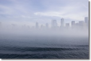
Weather Topic: What is Fog?
Home - Education - Cloud Types - Fog
 Next Topic: Fractus Clouds
Fog is technically a type of stratus cloud, which lies along the
ground and obscures visibility.
It is usually created when humidity in the air condenses into tiny water droplets.
Because of this, some places are more prone to foggy weather, such as regions
close to a body of water.
Fog is similar to mist; both are the appearance of water droplets suspended in
the air, but fog is the term applied to the condition when visibility is less than 1 km.
Next Topic: Fractus Clouds
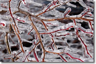
Weather Topic: What is Freezing Rain?
Home - Education - Precipitation - Freezing Rain
 Next Topic: Graupel
Freezing rain is a condition where precipitation which has fallen in the form of
water droplets reaches temperatures which are below freezing and freezes upon
coming into contact
with surface objects. The result of this precipitation is a glaze of ice which
can be damaging to plants and man-made structures. A severe onset of freezing
rain which results in a very thick glaze of ice is known as an ice storm.
Next Topic: Graupel
Current conditions powered by WeatherAPI.com


