Weather Alert in Alaska
Flood Advisory issued September 1 at 9:32PM AKDT until September 2 at 10:15AM AKDT by NWS Fairbanks AK
AREAS AFFECTED: Central Interior
DESCRIPTION: * WHAT...Flooding caused by persistent rainfall is expected. * WHERE...Tanana River near Manley Hot Springs. * WHEN...Until 1015 AM AKDT Tuesday. * IMPACTS...Minor flooding in low-lying and poor drainage areas. * ADDITIONAL DETAILS... - At 927 PM AKDT, minor flooding was observed by river gauge along the Tanana River at Manley Hot Springs. - The Tanana River at Manley Hot Springs has plateaued at its crest of 13.61 feet, which is minor flood stage. Water levels have remained at this level since about 5 AM AKDT Monday morning and have remained at this level longer than anticipated. Will extend the advisory through the overnight hours, though depending on how slow flood waters are to recede, may need to be extended again tomorrow morning. - Some locations that will experience flooding include... Manley Hot Springs. - For Tanana River at Manley Hot Springs-: At 7:00am the stage was 13.58 feet. Forecast: A crest around 13.7 feet is expected around 10:00am Monday. - http://www.weather.gov/aprfc
INSTRUCTION: Stay tuned to further developments by listening to your local radio, television, or NOAA Weather Radio for further information.
Want more detail? Get the Complete 7 Day and Night Detailed Forecast!
Current U.S. National Radar--Current
The Current National Weather Radar is shown below with a UTC Time (subtract 5 hours from UTC to get Eastern Time).

National Weather Forecast--Current
The Current National Weather Forecast and National Weather Map are shown below.

National Weather Forecast for Tomorrow
Tomorrow National Weather Forecast and Tomorrow National Weather Map are show below.

North America Water Vapor (Moisture)
This map shows recent moisture content over North America. Bright and colored areas show high moisture (ie, clouds); brown indicates very little moisture present; black indicates no moisture.

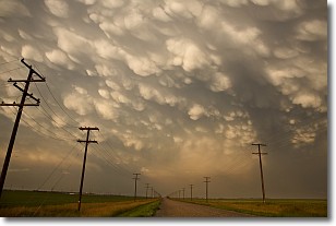
Weather Topic: What are Mammatus Clouds?
Home - Education - Cloud Types - Mammatus Clouds
 Next Topic: Nimbostratus Clouds
A mammatus cloud is a cloud with a unique feature which resembles
a web of pouches hanging along the base of the cloud.
In the United States, mammatus clouds tend to form in the warmer months, commonly
in the Midwest and eastern regions.
While they usually form at the bottom of a cumulonimbis cloud, they can also form
under altostratus, altocumulus, stratocumulus, and cirrus clouds. Mammatus clouds
warn that severe weather is close.
Next Topic: Nimbostratus Clouds
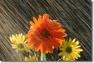
Weather Topic: What is Precipitation?
Home - Education - Precipitation - Precipitation
 Next Topic: Rain
Precipitation can refer to many different forms of water that
may fall from clouds. Precipitation occurs after a cloud has become saturated to
the point where its water particles are more dense than the air below the cloud.
In most cases, precipitation will reach the ground, but it is not uncommon for
precipitation to evaporate before it reaches the earth's surface.
When precipitation evaporates before it contacts the ground it is called Virga.
Graupel, hail, sleet, rain, drizzle, and snow are forms of precipitation, but fog
and mist are not considered precipitation because the water vapor which
constitutes them isn't dense enough to fall to the ground.
Next Topic: Rain
Current conditions powered by WeatherAPI.com


