Weather Alert in Alaska
Flood Advisory issued September 1 at 9:48AM AKDT until September 4 at 9:15AM AKDT by NWS Anchorage AK
AREAS AFFECTED: Western Susitna Valley; Central Susitna Valley; Northern Susitna Valley
DESCRIPTION: * WHAT...Flooding caused by excessive rainfall is expected. * WHERE...Northern Susitna Valley in the Petersville area * WHEN...Until 915 AM AKDT Thursday. * IMPACTS...Minor flooding in low-lying and poor drainage areas. Rises in small streams. Some low-water crossings may become impassable. River or stream flows are elevated. * ADDITIONAL DETAILS... - 1 to 3 inches of rainfall is expected today (Monday) into tonight (Monday night). The heaviest rain is expected to occur across the headwaters of Peters Creek and Cache Creek. After a lull in rain on Tuesday, another round of rain set to occur on Wednesday is expected to bring another inch of rainfall. - Area creeks and streams are already running higher than normal after the rainfall from last week. While waters have been receding, additional rainfall may result in rises again this week. - Streams that may be affected include Peters Creek, Cache Creek, Moose Creek, Kroto Creek, and other nearby streams and their tributaries. Larger rivers such as that Yentna and Susitna are NOT expected to rise into flood stage again. - http://www.weather.gov/safety/flood
INSTRUCTION: Stay tuned to further developments by listening to your local radio, television, or NOAA Weather Radio for further information. Turn around, don't drown when encountering flooded roads. Most flood deaths occur in vehicles. Flooding is occurring or is imminent. It is important to know where you are relative to streams, rivers, or creeks which can become killers in heavy rains. Campers and hikers should avoid streams or creeks.
Want more detail? Get the Complete 7 Day and Night Detailed Forecast!
Current U.S. National Radar--Current
The Current National Weather Radar is shown below with a UTC Time (subtract 5 hours from UTC to get Eastern Time).

National Weather Forecast--Current
The Current National Weather Forecast and National Weather Map are shown below.

National Weather Forecast for Tomorrow
Tomorrow National Weather Forecast and Tomorrow National Weather Map are show below.

North America Water Vapor (Moisture)
This map shows recent moisture content over North America. Bright and colored areas show high moisture (ie, clouds); brown indicates very little moisture present; black indicates no moisture.

Weather Topic: What are Cirrus Clouds?
Home - Education - Cloud Types - Cirrus Clouds
 Next Topic: Condensation
Cirrus clouds are high-level clouds that occur above 20,000 feet
and are composed mainly of ice crystals.
They are thin and wispy in appearance.
What do they indicate?
They are often the first sign of an approaching storm.
Next Topic: Condensation
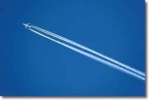
Weather Topic: What are Contrails?
Home - Education - Cloud Types - Contrails
 Next Topic: Cumulonimbus Clouds
A contrail is an artificial cloud, created by the passing of an
aircraft.
Contrails form because water vapor in the exhaust of aircraft engines is suspended
in the air under certain temperatures and humidity conditions. These contrails
are called exhaust contrails.
Another type of contrail can form due to a temporary reduction in air pressure
moving over the plane's surface, causing condensation.
These are called aerodynamic contrails.
When you can see your breath on a cold day, it is also because of condensation.
The reason contrails last longer than the condensation from your breath is
because the water in contrails freezes into ice particles.
Next Topic: Cumulonimbus Clouds
Current conditions powered by WeatherAPI.com


