Weather Alert in California
Winter Weather Advisory issued February 16 at 10:26AM PST until February 18 at 4:00PM PST by NWS Eureka CA
AREAS AFFECTED: Northwestern Mendocino Interior; Northeastern Mendocino Interior; Northern Lake County; Southern Lake County
DESCRIPTION: * WHAT...Snow expected elevations above 2500 feet. Total snow accumulations up to 14 inches. Winds gusting as high as 40 mph. * WHERE...Lake County, and Northern Mendocino Interior. * WHEN...From 10 PM this evening to 4 PM PST Wednesday. * IMPACTS...Roads, and especially bridges and overpasses, will likely become slick and hazardous. Travel could be very difficult. The hazardous conditions will impact the Tuesday morning and evening commutes. * ADDITIONAL DETAILS...There is still quite a bit of uncertainty on how low the snow levels will get. Tuesday morning there may be snow at Lake level in Lake county. Highway 101 may see snow, especially north of Ukiah.
INSTRUCTION: Slow down and use caution while traveling. The latest road conditions for the state you are calling from can be obtained by calling 5 1 1. Persons are urged to stay indoors until conditions improve. If you must go outside, dress in layers. Several layers of clothes will keep you warmer than a single heavy coat. Cover exposed skin to reduce your risk of frostbite or hypothermia. Gloves, a scarf, and a hat will keep you from losing your body heat. Be prepared for slippery roads. Slow down and use caution while driving. If you are going outside, watch your first few steps taken on stairs, sidewalks, and driveways. These surfaces could be icy and slippery, increasing your risk of a fall and injury.
Want more detail? Get the Complete 7 Day and Night Detailed Forecast!
Current U.S. National Radar--Current
The Current National Weather Radar is shown below with a UTC Time (subtract 5 hours from UTC to get Eastern Time).

National Weather Forecast--Current
The Current National Weather Forecast and National Weather Map are shown below.

National Weather Forecast for Tomorrow
Tomorrow National Weather Forecast and Tomorrow National Weather Map are show below.

North America Water Vapor (Moisture)
This map shows recent moisture content over North America. Bright and colored areas show high moisture (ie, clouds); brown indicates very little moisture present; black indicates no moisture.

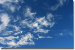
Weather Topic: What are Cirrostratus Clouds?
Home - Education - Cloud Types - Cirrostratus Clouds
 Next Topic: Cirrus Clouds
Cirrostratus clouds are high, thin clouds that form above
20,000 feet and are made mostly of ice crystals. They sometimes look like giant
feathers, horse tails, or curls of hair in the sky.
These clouds are pushed by the jet stream and can move at high speeds reaching
100 mph.
What do they indicate?
They indicate that a precipitation is likely within 24 hours.
Next Topic: Cirrus Clouds
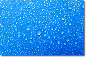
Weather Topic: What is Condensation?
Home - Education - Precipitation - Condensation
 Next Topic: Contrails
Condensation is the process which creates clouds, and therefore
it is a crucial process in the water cycle.
Condensation is the change of matter from a state of gas into a state of liquid,
and it happens because water molecules release heat into the atmosphere and
become organized into a more closely packed structure, what we might see as
water droplets.
Water is always present in the air around us as a vapor, but it's too small for
us to see. When water undergoes the process of condensation it becomes organized
into visible water droplets. You've probably seen condensation happen before on the
surface of a cold drink!
Next Topic: Contrails
Current conditions powered by WeatherAPI.com


