Weather Alert in California
Flood Watch issued February 16 at 1:37PM PST until February 17 at 12:00AM PST by NWS Los Angeles/Oxnard CA
AREAS AFFECTED: Catalina and Santa Barbara Islands; Santa Clarita Valley; Santa Ynez Valley; Santa Barbara County Southwestern Coast; Santa Barbara County Southeastern Coast; Santa Ynez Mountains Western Range; Santa Ynez Mountains Eastern Range; Santa Barbara County Interior Mountains; Ventura County Beaches; Ventura County Inland Coast; Lake Casitas; Ojai Valley; Central Ventura County Valleys; Malibu Coast; Los Angeles County Beaches; Palos Verdes Hills; Los Angeles County Inland Coast including Downtown Los Angeles; Western Santa Monica Mountains Recreational Area; Eastern Santa Monica Mountains Recreational Area; Calabasas and Agoura Hills; Western San Fernando Valley; Eastern San Fernando Valley; Southeastern Ventura County Valleys; Santa Susana Mountains; Southern Ventura County Mountains; Northern Ventura County Mountains; Interstate 5 Corridor; Western San Gabriel Mountains and Highway 14 Corridor; Eastern San Gabriel Mountains; Los Angeles County San Gabriel Valley; San Miguel and Santa Rosa Islands; Santa Cruz and Anacapa Islands
DESCRIPTION: * WHAT...Flooding caused by excessive rainfall is possible. Rock and mud slides are possible near steep terrain. Debris flows are possible on burn scars. * WHERE...Much of southwest California. * WHEN...Until midnight PST tonight. * IMPACTS...Flash flooding is possible. Excessive runoff may result in flooding of low-lying and flood-prone locations, including creeks and streams. Flooding may occur in poor drainage and urban areas. Low-water crossings may be flooded. Extensive street flooding is possible. * ADDITIONAL DETAILS... - Showers and thunderstorms are possible overnight tonight with locally heavy rain at times. - http://www.weather.gov/safety/flood
INSTRUCTION: You should monitor later forecasts and be alert for possible Flood Warnings. Those living in areas prone to flooding should be prepared to take action should flooding develop. Travel through passes and canyons could become dangerous, and be alert for rock slides and mud slides. Follow the direction of Emergency Management and Law Enforcement officials.
Want more detail? Get the Complete 7 Day and Night Detailed Forecast!
Current U.S. National Radar--Current
The Current National Weather Radar is shown below with a UTC Time (subtract 5 hours from UTC to get Eastern Time).

National Weather Forecast--Current
The Current National Weather Forecast and National Weather Map are shown below.

National Weather Forecast for Tomorrow
Tomorrow National Weather Forecast and Tomorrow National Weather Map are show below.

North America Water Vapor (Moisture)
This map shows recent moisture content over North America. Bright and colored areas show high moisture (ie, clouds); brown indicates very little moisture present; black indicates no moisture.

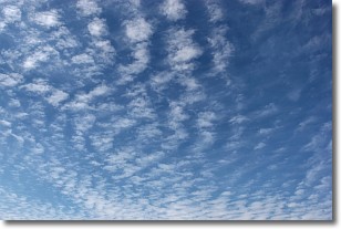
Weather Topic: What are Cirrocumulus Clouds?
Home - Education - Cloud Types - Cirrocumulus Clouds
 Next Topic: Cirrostratus Clouds
Cirrocumulus clouds form at high altitudes (usually around 5 km)
and have distinguishing characteristics displayed in a fine layer of
small cloud patches. These small cloud patches are sometimes referred to as
"cloudlets" in relation to the whole cloud formation.
Cirrocumulus clouds are formed from ice crystals and water droplets. Often, the
water droplets in the cloud freeze into ice crystals and the cloud becomes a
cirrostratus cloud. Because of this common occurrence, cirrocumulus cloud
formations generally pass rapidly.
Next Topic: Cirrostratus Clouds
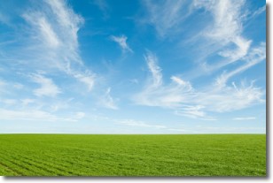
Weather Topic: What are Cirrus Clouds?
Home - Education - Cloud Types - Cirrus Clouds
 Next Topic: Condensation
Cirrus clouds are high-level clouds that occur above 20,000 feet
and are composed mainly of ice crystals.
They are thin and wispy in appearance.
What do they indicate?
They are often the first sign of an approaching storm.
Next Topic: Condensation
Current conditions powered by WeatherAPI.com


