Weather Alert in North Carolina
Special Weather Statement issued March 30 at 4:17AM EDT by NWS Raleigh NC
AREAS AFFECTED: Person; Granville; Vance; Warren; Halifax; Forsyth; Guilford; Alamance; Orange; Durham; Franklin; Nash; Edgecombe; Davidson; Randolph; Chatham; Wake; Johnston; Wilson; Stanly; Montgomery; Moore; Lee; Harnett; Wayne; Anson; Richmond; Scotland; Hoke; Cumberland; Sampson
DESCRIPTION: The combination of low relative humidity, gusty winds, and very dry fuels will lead to an increased risk of wildfires today across central North Carolina. Residents and visitors are urged to properly dispose of cigarette butts, matches, and any other flammable items in appropriate containers. Additionally, exercise caution if operating any equipment that could create sparks, and keep vehicles off of dry leaves and grass. Most dry grasses, dead leaves, and other tree litter could easily ignite and spread fire quickly. A statewide burn ban issued by the North Carolina Forest Service is currently in place. Open burning of any kind is illegal.
INSTRUCTION: N/A
Want more detail? Get the Complete 7 Day and Night Detailed Forecast!
Current U.S. National Radar--Current
The Current National Weather Radar is shown below with a UTC Time (subtract 5 hours from UTC to get Eastern Time).

National Weather Forecast--Current
The Current National Weather Forecast and National Weather Map are shown below.

National Weather Forecast for Tomorrow
Tomorrow National Weather Forecast and Tomorrow National Weather Map are show below.

North America Water Vapor (Moisture)
This map shows recent moisture content over North America. Bright and colored areas show high moisture (ie, clouds); brown indicates very little moisture present; black indicates no moisture.

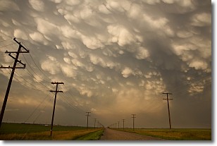
Weather Topic: What are Mammatus Clouds?
Home - Education - Cloud Types - Mammatus Clouds
 Next Topic: Nimbostratus Clouds
A mammatus cloud is a cloud with a unique feature which resembles
a web of pouches hanging along the base of the cloud.
In the United States, mammatus clouds tend to form in the warmer months, commonly
in the Midwest and eastern regions.
While they usually form at the bottom of a cumulonimbis cloud, they can also form
under altostratus, altocumulus, stratocumulus, and cirrus clouds. Mammatus clouds
warn that severe weather is close.
Next Topic: Nimbostratus Clouds
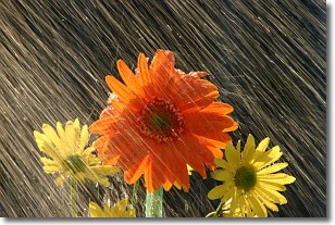
Weather Topic: What is Precipitation?
Home - Education - Precipitation - Precipitation
 Next Topic: Rain
Precipitation can refer to many different forms of water that
may fall from clouds. Precipitation occurs after a cloud has become saturated to
the point where its water particles are more dense than the air below the cloud.
In most cases, precipitation will reach the ground, but it is not uncommon for
precipitation to evaporate before it reaches the earth's surface.
When precipitation evaporates before it contacts the ground it is called Virga.
Graupel, hail, sleet, rain, drizzle, and snow are forms of precipitation, but fog
and mist are not considered precipitation because the water vapor which
constitutes them isn't dense enough to fall to the ground.
Next Topic: Rain
Current conditions powered by WeatherAPI.com


