Weather Alert in New Jersey
Special Weather Statement issued February 28 at 2:34AM EST by NWS Upton NY
AREAS AFFECTED: Western Passaic; Eastern Passaic; Hudson; Western Bergen; Eastern Bergen; Western Essex; Eastern Essex; Western Union; Eastern Union; Orange; Putnam; Rockland; Northern Westchester; Southern Westchester; New York (Manhattan); Bronx; Richmond (Staten Is.); Kings (Brooklyn); Northwest Suffolk; Northeast Suffolk; Southwest Suffolk; Southeast Suffolk; Northern Queens; Northern Nassau; Southern Queens; Southern Nassau
DESCRIPTION: Areas of fog have developed over portions of the region and are expected to expand early this morning, lingering into mid- morning. At the same time, temperatures in most spots will be at or below freezing. This combination, along with any refreezing of melted snow, could result in slippery conditions of untreated surfaces due to black ice. Use caution if traveling this morning as black ice can make conditions very slick. Locally reduced visibility will be possible as well. Leave extra room between you and the car in front of you. Additionally, pedestrians should use caution walking on any untreated surfaces.
INSTRUCTION: N/A
Want more detail? Get the Complete 7 Day and Night Detailed Forecast!
Current U.S. National Radar--Current
The Current National Weather Radar is shown below with a UTC Time (subtract 5 hours from UTC to get Eastern Time).

National Weather Forecast--Current
The Current National Weather Forecast and National Weather Map are shown below.

National Weather Forecast for Tomorrow
Tomorrow National Weather Forecast and Tomorrow National Weather Map are show below.

North America Water Vapor (Moisture)
This map shows recent moisture content over North America. Bright and colored areas show high moisture (ie, clouds); brown indicates very little moisture present; black indicates no moisture.

Weather Topic: What is Graupel?
Home - Education - Precipitation - Graupel
 Next Topic: Hail
Graupel is a form of precipitation that is created by atmospheric conditions
which cause supercooled water droplets to contact snow crystals and freeze to
their surface.
Sometimes known as soft hail or snow pellets, graupel is delicate and easily
destroyed by touch. Whereas hail usually falls during severe weather, graupel
doesn't require such conditions to form, and can form in mild precipitation
similar to situations which produce snowfall.
Next Topic: Hail
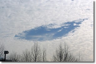
Weather Topic: What are Hole Punch Clouds?
Home - Education - Cloud Types - Hole Punch Clouds
 Next Topic: Mammatus Clouds
A hole punch cloud is an unusual occurrence when a disk-shaped
hole appears in a cirrostratus, cirrocumulus, or altocumulus cloud.
When part of the cloud forms ice crystals, water droplets in the surrounding area
of the cloud evaporate. The effect of this process produces a large elliptical
gap in the cloud. The hole punch cloud formation is rare, but it is not specific
to any geographic area.
Other names which have been used to describe this phenomena include fallstreak hole,
skypunch, and cloud hole.
Next Topic: Mammatus Clouds
Current conditions powered by WeatherAPI.com


