Weather Alert in California
Air Quality Alert issued September 4 at 8:01AM PDT by NWS Hanford CA
AREAS AFFECTED: Fresno, CA; Kern, CA; Kings, CA; Madera, CA; Merced, CA; San Joaquin, CA; Stanislaus, CA; Tulare, CA
DESCRIPTION: The Valley Air District is issuing an Air Quality Alert on September 3, 2025, due to smoke impacts from wildfires in California including the Garnet Fire, the Marmon Fire, the Salt 11-2 Fire, and the TCU September Lightning Complex for San Joaquin, Stanislaus, Merced, Madera, Fresno, Kings, Tulare, and the Valley portion of Kern Counties. This Air Quality Alert is in effect until the fires are extinguished. Exposure to particle pollution can cause serious health problems, aggravate lung disease, cause asthma attacks and acute bronchitis, and increase risk of respiratory infections. Residents are advised to use caution as conditions warrant. People with heart or lung diseases should follow their doctors advice for dealing with episodes of unhealthy air quality. Additionally, older adults and children should avoid prolonged exposure, strenuous activities or heavy exertion, as conditions dictate. For additional information, call your local San Joaquin Valley Air District office. Modesto 209-557-6400, Fresno 559-230-6000, Bakersfield 661-392-5500 Residents can also follow air quality conditions by downloading the free Valley Air app, available in the Apple store or Google Play, or by visiting the AirNow Fire and Smoke Map at fire.airnow.gov.
INSTRUCTION: N/A
Want more detail? Get the Complete 7 Day and Night Detailed Forecast!
Current U.S. National Radar--Current
The Current National Weather Radar is shown below with a UTC Time (subtract 5 hours from UTC to get Eastern Time).

National Weather Forecast--Current
The Current National Weather Forecast and National Weather Map are shown below.

National Weather Forecast for Tomorrow
Tomorrow National Weather Forecast and Tomorrow National Weather Map are show below.

North America Water Vapor (Moisture)
This map shows recent moisture content over North America. Bright and colored areas show high moisture (ie, clouds); brown indicates very little moisture present; black indicates no moisture.

Weather Topic: What is Hail?
Home - Education - Precipitation - Hail
 Next Topic: Hole Punch Clouds
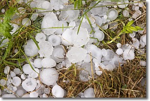
Hail is a form of precipitation which is recognized by large solid balls or
clumps of ice. Hail is created by thunderstorm clouds with strong updrafts of wind.
As the hailstones remain in the updraft, ice is deposited onto them until their
weight becomes heavy enough for them to fall to the earth's surface.
Hail storms can cause significant damage to crops, aircrafts, and man-made structures,
despite the fact that the duration is usually less than ten minutes.
Next Topic: Hole Punch Clouds
Weather Topic: What are Mammatus Clouds?
Home - Education - Cloud Types - Mammatus Clouds
 Next Topic: Nimbostratus Clouds
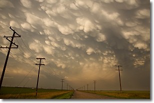
A mammatus cloud is a cloud with a unique feature which resembles
a web of pouches hanging along the base of the cloud.
In the United States, mammatus clouds tend to form in the warmer months, commonly
in the Midwest and eastern regions.
While they usually form at the bottom of a cumulonimbis cloud, they can also form
under altostratus, altocumulus, stratocumulus, and cirrus clouds. Mammatus clouds
warn that severe weather is close.
Next Topic: Nimbostratus Clouds
Current conditions powered by WeatherAPI.com


