Weather Alert in Hawaii
Flood Advisory issued February 7 at 8:56PM HST until February 8 at 12:00AM HST by NWS Honolulu HI
AREAS AFFECTED: Hawaii in Hawaii, HI
DESCRIPTION: * WHAT...Flooding caused by excessive rainfall. * WHERE...The island of Hawaii in Hawaii County. * WHEN...Until midnight HST tonight. * IMPACTS...Minor flooding on roads, poor drainage areas, and in streams. * ADDITIONAL DETAILS... - At 855 PM HST, radar indicated moderate to heavy rain over windward Big Island, with the heaviest rain in and around Hilo, as well as along the Hamakua Coast between Upolu Point and Laupahoehoe. Rain was falling at a rate of 1 to 2 inches per hour in the heaviest showers. - Some locations that will experience flooding include... Hilo, Hawaiian Paradise Park, Kapaau, Honokaa, Honomu, Papaikou, Pepeekeo, Hakalau, Ninole, Mountain View, Laupahoehoe, Glenwood, Volcano, Ookala, Keaau, Paauilo, Hawaiian Acres, Orchidlands Estates and Hawaii Volcanoes National Park.
INSTRUCTION: Stay away from streams, drainage ditches and low lying areas prone to flooding. A Flood Watch is also in effect until 6 PM HST Monday.
Want more detail? Get the Complete 7 Day and Night Detailed Forecast!
Current U.S. National Radar--Current
The Current National Weather Radar is shown below with a UTC Time (subtract 5 hours from UTC to get Eastern Time).

National Weather Forecast--Current
The Current National Weather Forecast and National Weather Map are shown below.

National Weather Forecast for Tomorrow
Tomorrow National Weather Forecast and Tomorrow National Weather Map are show below.

North America Water Vapor (Moisture)
This map shows recent moisture content over North America. Bright and colored areas show high moisture (ie, clouds); brown indicates very little moisture present; black indicates no moisture.

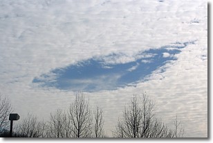
Weather Topic: What are Hole Punch Clouds?
Home - Education - Cloud Types - Hole Punch Clouds
 Next Topic: Mammatus Clouds
A hole punch cloud is an unusual occurrence when a disk-shaped
hole appears in a cirrostratus, cirrocumulus, or altocumulus cloud.
When part of the cloud forms ice crystals, water droplets in the surrounding area
of the cloud evaporate. The effect of this process produces a large elliptical
gap in the cloud. The hole punch cloud formation is rare, but it is not specific
to any geographic area.
Other names which have been used to describe this phenomena include fallstreak hole,
skypunch, and cloud hole.
Next Topic: Mammatus Clouds
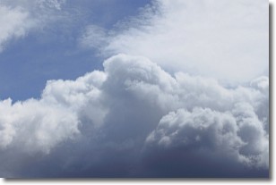
Weather Topic: What are Nimbostratus Clouds?
Home - Education - Cloud Types - Nimbostratus Clouds
 Next Topic: Precipitation
A nimbostratus cloud is similar to a stratus cloud in its formless,
smooth appearance. However, a nimbostratus cloud is darker than a stratus cloud,
because it is thicker.
Unlike a stratus cloud, a nimbostratus cloud typically brings with it the threat
of moderate to heavy precipitation. In some cases, the precipitation may evaporate
before reaching the ground, a phenomenon known as virga.
Next Topic: Precipitation
Current conditions powered by WeatherAPI.com


