Weather Alerts for Colorado
1. Avalanche Warning for: West Elk and Sawatch Mountains
2. Avalanche Watch for: Elkhead and Park Mountains; Northwestern San Juan Mountains; Southwest San Juan Mountains; West Jackson and West Grand Counties Above 9000 Feet; Eastern San Juan Mountains Above 10000 Ft
3. Avalanche Watch for: Grand and Battlement Mesas; Gore and Elk Mountains/Central Mountain Valleys; Flat Tops
4. Avalanche Watch for: Grand and Battlement Mesas; Gore and Elk Mountains/Central Mountain Valleys; Flat Tops
5. Fire Weather Watch for: Crowley County Including Ordway; Otero County Including La Junta and Western Comanche Grasslands; Eastern Las Animas County Including Pinon Canyon; Kiowa County Including Eads; Bent County Including Las Animas; Prowers County Including Lamar; Baca County Including Springfield and Eastern Comanche Grasslands
6. Fire Weather Watch for: Pueblo County Including Pueblo; Huerfano County Including Walsenburg; Western Las Animas County Including Trinidad and Thatcher
7. High Wind Warning for: Canon City Vicinity/Eastern Fremont County; Pueblo Vicinity/Pueblo County Below 6300 Feet; Trinidad Vicinity/Western Las Animas County Below 7500 Ft; Crowley County; La Junta Vicinity/Otero County; Eastern Las Animas County; Western Kiowa County; Eastern Kiowa County; Las Animas Vicinity/Bent County; Lamar Vicinity/Prowers County; Springfield Vicinity/Baca County
8. High Wind Warning for: Del Norte Vicinity/Northern San Luis Valley Below 8500 Ft; Alamosa Vicinity/Central San Luis Valley Below 8500 Ft; Southern San Luis Valley
9. High Wind Warning for: Larimer County Below 6000 Feet/Northwest Weld County; Northeast Weld County; Central and South Weld County; Morgan County; Central and East Adams and Arapahoe Counties; North and Northeast Elbert County Below 6000 Feet/North Lincoln County; Southeast Elbert County Below 6000 Feet/South Lincoln County; Logan County; Washington County; Sedgwick County; Phillips County
10. High Wind Warning for: Northern El Paso County/Monument Ridge/Rampart Range Below 7500 Ft; Colorado Springs Vicinity/Southern El Paso County/Rampart Range Below 7400 Ft
11. High Wind Warning for: Northern Sangre de Cristo Mountains Between 8500 And 11000 Ft; Northern Sangre de Cristo Mountains above 11000 Ft; Southern Sangre De Cristo Mountains Between 7500 and 11000 Ft; Southern Sangre De Cristo Mountains Above 11000 Ft; Western/Central Fremont County Below 8500 Ft; Wet Mountain Valley Below 8500 Ft; Wet Mountains between 6300 and 10000Ft; Wet Mountains above 10000 Ft; Walsenburg Vicinity/Upper Huerfano River Basin Below 7500 Ft
12. High Wind Warning for: Yuma County; Kit Carson County; Cheyenne County; Sherman; Thomas; Wallace; Logan; Gove; Greeley; Wichita
13. Red Flag Warning for: Crowley County Including Ordway; Otero County Including La Junta and Western Comanche Grasslands; Eastern Las Animas County Including Pinon Canyon; Kiowa County Including Eads; Bent County Including Las Animas; Prowers County Including Lamar; Baca County Including Springfield and Eastern Comanche Grasslands
14. Red Flag Warning for: Elbert/Central and East Douglas Counties Above 6000 Feet; Central and East Adams and Arapahoe Counties; North and Northeast Elbert County Below 6000 Feet/North Lincoln County; Southeast Elbert County Below 6000 Feet/South Lincoln County; Washington County
15. Red Flag Warning for: Larimer County Below 6000 Feet/Northwest Weld County; Boulder And Jefferson Counties Below 6000 Feet/West Broomfield County; North Douglas County Below 6000 Feet/Denver/West Adams and Arapahoe Counties/East Broomfield County; Northeast Weld County; Central and South Weld County; Morgan County; Logan County; Sedgwick County; Phillips County
16. Red Flag Warning for: Northern El Paso County Including Monument and Black Forest; Southern El Paso County Including Fort Carson and Colorado Springs
17. Red Flag Warning for: Pueblo County Including Pueblo; Huerfano County Including Walsenburg; Western Las Animas County Including Trinidad and Thatcher
18. Red Flag Warning for: Yuma; Kit Carson County; Cheyenne; Cheyenne; Rawlins; Sherman; Wallace; Greeley; Dundy; Hitchcock
19. Wind Advisory for: Debeque to Silt Corridor; Central Colorado River Basin; Upper Gunnison River Valley
20. Wind Advisory for: Lower Yampa River Basin; Central Yampa River Basin; Paradox Valley/Lower Dolores River; Four Corners/Upper Dolores River; Animas River Basin
21. Winter Storm Warning for: Eastern Sawatch Mountains above 11000 Ft; Eastern San Juan Mountains Above 10000 Ft
22. Winter Storm Warning for: Elkhead and Park Mountains
23. Winter Storm Warning for: Gore and Elk Mountains/Central Mountain Valleys; Flat Tops
24. Winter Storm Warning for: Grand and Battlement Mesas; West Elk and Sawatch Mountains
25. Winter Storm Warning for: Northwestern San Juan Mountains; Southwest San Juan Mountains
26. Winter Storm Warning for: Roan and Tavaputs Plateaus
27. Winter Storm Warning for: Uncompahgre Plateau/Dallas Divide
28. Winter Storm Warning for: West Jackson and West Grand Counties Above 9000 Feet
29. Winter Weather Advisory for: Jackson County Below 9000 Feet; Grand and Summit Counties Below 9000 Feet; South and East Jackson/Larimer/North and Northeast Grand/Northwest Boulder Counties Above 9000 Feet; South and Southeast Grand/West Central and Southwest Boulder/Gilpin/Clear Creek/Summit/North and West Park Counties Above 9000 Feet
30. Winter Weather Advisory for: Northern Sangre de Cristo Mountains Between 8500 And 11000 Ft; Northern Sangre de Cristo Mountains above 11000 Ft; Southern Sangre De Cristo Mountains Between 7500 and 11000 Ft; Southern Sangre De Cristo Mountains Above 11000 Ft
31. Winter Weather Advisory for: San Juan River Basin
32. Winter Weather Advisory for: Upper Yampa River Basin
33. Winter Weather Advisory for: Western Mosquito Range/East Lake County Above 11000 Ft; Leadville Vicinity/Lake County Below 11000 Ft; Western Chaffee County Between 9000 and 11000 Ft; La Garita Mountains Above 10000 Ft; Upper Rio Grande Valley/Eastern San Juan Mountains Below 10000 Ft
Want more detail? Get the Complete 7 Day and Night Detailed Forecast!
Current U.S. National Radar--Current
The Current National Weather Radar is shown below with a UTC Time (subtract 5 hours from UTC to get Eastern Time).

National Weather Forecast--Current
The Current National Weather Forecast and National Weather Map are shown below.

National Weather Forecast for Tomorrow
Tomorrow National Weather Forecast and Tomorrow National Weather Map are show below.

North America Water Vapor (Moisture)
This map shows recent moisture content over North America. Bright and colored areas show high moisture (ie, clouds); brown indicates very little moisture present; black indicates no moisture.

Weather Topic: What is Drizzle?
Home - Education - Precipitation - Drizzle
 Next Topic: Evaporation
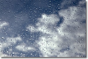
Drizzle is precipitation in the form of water droplets which are
smaller than raindrops.
Drizzle is characterized by fine, gently falling droplets and typically does not
impact human habitation in a negative way. The exception to this is freezing drizzle,
a condition where drizzle freezes immediately upon reaching earth's surface.
Freezing drizzle is still less dangerous than freezing rain, but can
potentially result in hazardous road conditions.
Next Topic: Evaporation
Weather Topic: What is Fog?
Home - Education - Cloud Types - Fog
 Next Topic: Fractus Clouds
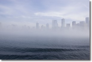
Fog is technically a type of stratus cloud, which lies along the
ground and obscures visibility.
It is usually created when humidity in the air condenses into tiny water droplets.
Because of this, some places are more prone to foggy weather, such as regions
close to a body of water.
Fog is similar to mist; both are the appearance of water droplets suspended in
the air, but fog is the term applied to the condition when visibility is less than 1 km.
Next Topic: Fractus Clouds
Current conditions powered by WeatherAPI.com


